Hiking in Dubrovnik and the wider Dubrovnik-Neretva County ranges from short viewpoint walks above the Old Town to forest trails and full-day mountain routes. The most popular options include the Mount Srđ zigzag path, the Velika and Mala Petka hill trails above Lapad Bay, shaded walks on Lokrum Island and longer routes in the Konavle hills.
If you want a short hike with excellent panoramas, start from the foothills of Dubrovnik and follow the old road and zigzag trail towards Napoleon’s Fort Imperial on Mount Srđ. The route is well known, not technically demanding, and suitable for most visitors with basic fitness. From the top you get wide views over the city walls, Lokrum and the Elaphiti Islands.
For quieter paths and a more local feel, Velika and Mala Petka above Lapad offer easy forest tracks and viewpoints over Lapad Bay, while Lokrum Island has marked walking routes through pine woods and along the rocky coast. More experienced hikers can look further into Dubrovnik-Neretva County, with longer routes in the Konavle countryside, on Mount Snježnica or on nearby island trails such as Mljet.
Panoramic Sunset Hike to Mount Srđ with amazing views of Old Town Dubrovnik
The most beautiful hike overlooking Old Town Dubrovnik
Experience the ultimate blend of outdoor activity, historical discovery and breathtaking Old Town Dubrovnik vistas as you embark on this all-in-one tour to the top of Mount Srđ. Delight in wine, sunset views, and local snacks in the peaceful seclusion of a private setting, away from the crowds.
Hiking in Dubrovnik - short facts
Hiking around Dubrovnik is straightforward and doesn’t require special equipment. Most routes start close to the Old Town or on the Lapad peninsula, making them easy to add to a day of sightseeing. Expect short to medium-length walks, open views and rocky Mediterranean terrain.
The best-known route is the hike up Mount Srđ, the hill directly above the Old Town. The zigzag path is steady rather than technical and takes roughly 2 to 3 hours for a relaxed return walk, including time at Fort Imperial on the top. The trail is exposed to the sun, so good shoes and water are important.
Lapad’s Velika and Mala Petka hills offer quieter, shaded paths with sea views, usually taking about an hour or two. Lokrum Island has easy marked walks, including the short climb to Fort Royal and several coastal tracks that combine well with swimming or a half-day visit.
- Main viewpoints: Mount Srđ, Petka hill above Lapad, Fort Royal on Lokrum.
- Difficulty: mostly easy to moderate, with some rocky and exposed sections.
- Time needed: from short 1-hour loops to half-day outings.
- Best seasons: spring and autumn; in summer, go early or late to avoid heat.
- Good for: casual walkers, families with older children and anyone wanting clear views without a full mountain hike.
Quick answers: is hiking in Dubrovnik worth it?
Yes. Dubrovnik’s hikes are short, accessible and reward you with some of the best viewpoints in the region. Most routes start close to the city, so you can fit a walk into a half day without long travel or equipment.
- Best hike in Dubrovnik: Mount Srđ - the classic zigzag trail directly above the Old Town with wide coastal views.
- How long is the Mount Srđ hike?: Around 2 to 3 hours for a relaxed return walk, depending on pace.
- Is the trail difficult?: Moderate. Steady uphill on a rocky path, but manageable for most visitors with suitable footwear.
- Best time of day to hike: Early morning or late afternoon for cooler temperatures and softer light; sunset is especially popular.
- Suitable for beginners and families?: Yes, for those comfortable with uneven terrain. Petka hill and Lokrum paths offer easier alternatives.
Overview of main hikes around Dubrovnik
Dubrovnik has several walking and hiking routes within easy reach of the city. They range from short forest paths and coastal walks to the well-known ascent of Mount Srđ. Most are half-day outings and do not require special equipment beyond comfortable shoes, water and sun protection.
- Mount Srđ - the classic zigzag trail above the Old Town with open views and a steady uphill climb.
- Velika and Mala Petka - forested hills on the Lapad peninsula with shaded paths and viewpoints over Lapad Bay.
- Lokrum Island - easy marked routes to Fort Royal and along the rocky coast; ideal as a half-day walk with swimming.
- Srđ ridge to Fort Strinčjera - a quieter extension from the Fort Imperial area with gentle terrain and inland views.
- Coastal promenades and countryside paths - relaxed walking options in Cavtat or the Konavle area, suitable for all ages.
Mount Srđ hike - classic Dubrovnik viewpoint trail
Why hike Mount Srđ
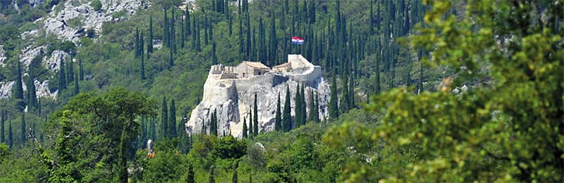
Mount Srđ is the most popular hike in Dubrovnik because it rises directly behind the Old Town, offering open views over the city walls, Lokrum Island and the Elaphiti Islands. The route is accessible, well known and easy to combine with sightseeing. At the top you can visit Fort Imperial, an important site from Dubrovnik’s recent history, and enjoy one of the best sunset spots in the area.
Trail overview: distance, duration and difficulty
The standard trail follows a series of wide zigzags from the base of the hill up to Fort Imperial. Most walkers take around 2 to 3 hours for a relaxed return trip, allowing for photo stops. The path is rocky but straightforward and is best described as a steady moderate climb. Good footwear, water and sun protection are important because the trail is fully exposed.
Trail map and main route options
The most used route starts at the lower slopes above the city and climbs the zigzag path directly to Fort Imperial. From the top you can continue along the ridge toward Fort Strinčjera for a quieter extension on gentler ground. An alternative is to walk up from the Bosanka side, a quieter approach that joins the upper section of the main path.
How to reach the Mount Srđ trailhead from the Old Town
You can reach the lower trailhead on foot from the Old Town in about 15 to 20 minutes. The start is above the city walls, on the inland side of Dubrovnik. Taxis also drop passengers near the base for a shorter approach. Public buses to areas above the Old Town can be used to get closer, but walking the final stretch is still required. All options involve a short approach to the clear zigzag path leading uphill.
What to expect on the trail
- Rocky, dry terrain typical of the Dalmatian coast.
- No shade, so temperatures rise quickly on sunny days.
- Frequent viewpoints as you climb, especially at the switchbacks.
- Simple navigation - the main path is obvious and well used.
Sunset hike tips
- Start the ascent early enough to reach the top before the sun drops; the upper viewpoints fill quickly on clear days.
- Consider hiking up and returning by cable car or bus if you prefer not to walk in the dark.
- If walking down after sunset, use a phone light and take extra care on the rocky sections.
- You can also combine the hike with the Dubrovnik Cable Car. Many visitors hike one way and use the cable car for the return trip, which is especially convenient after sunset.
Small-group Dubrovnik Sunset Hiking Tour
For visitors who want the Mount Srđ experience without planning the route or worrying about timing
A guided sunset hike is an easy way to enjoy the best views of Dubrovnik. The guide leads the way along the classic zigzag path, sharing stories about the city and the hillside above it while you focus on the scenery. It is also one of the most reliable ways to capture wide evening views of the Elaphiti Islands, the Old Town, Lokrum and the Lapad peninsula.
This small-group tour keeps the pace comfortable and provides a more personal experience than larger excursions. It includes a local tour leader, selected refreshments and time to visit Fort Imperial at the top.
Ronald Brown Path - Stražišće peak above Cavtat
Why hike the Ronald Brown Path
The Ronald Brown Path is one of the best full-day hikes in the wider Dubrovnik area. It climbs from the hills above Cavtat to Stražišće peak, where a memorial cross marks the site of a 1996 plane crash. From the top you get wide views over Cavtat, the Konavle countryside, Župa Bay and all the way towards Dubrovnik and the open sea.
Trail overview: distance, duration and difficulty
This is a longer route than Mount Srđ and feels like a proper mountain hike rather than a short viewpoint walk. Expect roughly 10 km out and back and allow around 4 to 5 hours in total, including breaks and time at the summit. The path follows an old stone military road, is mostly steady but has some steeper, rocky sections. It is best for regular walkers with reasonable fitness, sturdy shoes and no fear of heights.
Where the trail starts and how to get there from Dubrovnik
The marked route starts in the hamlet of Gornji Obod above Cavtat and continues via the village of Velji Do to the summit cross on Stražišće. From Dubrovnik you first travel to Cavtat by local bus or taxi, then continue uphill by road or on foot to the starting point. Many hikers shorten the approach by arranging a transfer directly to Velji Do, which reduces the amount of climbing and walking time.
What you see on the way
The Ronald Brown Path quickly gains height above Cavtat and the coast, so views open up early in the walk. As you climb, you look down over Cavtat’s peninsulas, the Konavle valleys and the islands off Dubrovnik. The terrain is mostly open, with low Mediterranean shrubs, occasional trees and stretches of old stone track. Near the top, the path reaches the memorial cross and viewpoint on Stražišće, a good place to rest, take photos and read the information boards about the site.
Safety and practical tips
- There is very little shade on the route and no reliable water on the trail, so start early in warm months and carry enough water for the whole hike.
- Wear proper hiking shoes - the stony path can be rough underfoot and slippery when wet.
- Check the weather before you set out and avoid this hike in strong wind, fog or thunderstorms.
- Take a fully charged phone and, if possible, an offline map app to follow the route, even though the trail is generally well marked.
- Plan your transport back to Dubrovnik in advance, especially if you finish later in the day and rely on local buses from Cavtat.
If you are staying in or near Cavtat, this hike is an excellent way to combine coastal time with a quieter, more remote mountain atmosphere above the Konavle region.
H.E.A.R.T. of Konavle - long-distance trail network
What is the H.E.A.R.T. trail
H.E.A.R.T. of Konavle is a marked long-distance hiking and running trail network in the Konavle region, southeast of Dubrovnik. The system links coastal areas, villages and the inland hills above Cavtat and Konavle, and is designed so you can walk individual routes or combine them into a multi-day adventure.
Main routes and distances
The H.E.A.R.T. network consists of three main interconnected routes that together create more than 100 km of marked hiking terrain across Konavle. Each route has its own character and difficulty level, and all share a clear, easy-to-follow navigation system.
- Grand Loop Route - 76.43 km (47.5 miles) with around 10,085 ft (about 3,070 m) of elevation gain. This is the core long-distance circuit that connects the coast, villages and high ground, best suited to experienced hikers or multi-day walkers.
- Blue Bypass - 15.20 km (9.4 miles) with around 3,192 ft (about 970 m) of elevation gain. A demanding side route that adds extra climbing and viewpoints, ideal for fitter hikers who want a tougher day out.
- Southernmost Point Trail - 14.92 km (9.3 miles) with around 935 ft (about 285 m) of elevation gain. A coastal-oriented option that takes you towards the southernmost parts of Croatia and is more manageable as a single full-day hike.
Together these routes make up roughly 106.55 km (66.2 miles) with about 14,212 ft (around 4,330 m) of elevation gain, giving you plenty of choice between long mountain-style days and shorter sections with easier profiles.
Trail navigation and markings
All H.E.A.R.T. routes are marked with a simple, consistent navigation system designed to make route finding straightforward. Red lines indicate the main route, blue lines mark bypasses or optional detours, and additional waymarks and signposts appear at key junctions. Directional arrows, painted markers and stage boards help you stay on track even in more open terrain.
Although the markings are clear and reliable, the organisers still recommend using the available GPX files, interactive map and offline navigation apps, especially in bad weather or low visibility. This combination makes the trail network accessible even for visitors who are not familiar with the Konavle area.
Trail character and who it is for
Compared with short Dubrovnik city hikes, the H.E.A.R.T. routes feel wilder and more remote. Sections follow old paths, farm tracks and quiet roads through vineyards, olive groves, karst ridges and traditional stone villages. They are best suited to regular hikers and trail runners who are comfortable with longer distances, uneven terrain and basic navigation.
How to reach the trail from Dubrovnik
The routes start and finish in the Konavle area, with convenient access points near Cavtat and several villages. From Dubrovnik you first travel to Cavtat or into Konavle by local bus, rental car or taxi. Many hikers choose to stay in or around Cavtat and then pick individual stages or loops that begin nearby or can be reached with a short transfer.
Navigation, season and when to go
The H.E.A.R.T. network is waymarked on the ground and supported by detailed GPX files and online maps. Even so, you should not rely only on trail signs. Bring a fully charged phone, offline maps and be prepared for open, rocky terrain. Spring and autumn are the most comfortable seasons, with milder temperatures and longer days. In summer, plan very early starts, shorter stages and carry extra water.
Safety and practical tips
- Carry enough water and food for the whole day, as shops and fountains are not always available on route.
- Wear sturdy hiking shoes and sun protection; many sections are exposed and stony underfoot.
- Check the latest route descriptions, GPX files and any trail updates before you go.
- Avoid long stages in poor weather, especially strong wind, fog or storms on exposed ridges.
- Plan your end point and transport back to your base in advance, particularly if you rely on local buses.
For detailed stage descriptions, updated maps and GPX downloads, visit the official H.E.A.R.T. of Konavle website at konavle-hiking-trails.com.
Other hikes and scenic walks around Dubrovnik
Beyond Mount Srđ and the central city routes, several good hiking and walking options can be found in the nearby areas of Lapad, Župa dubrovačka, Cavtat and Konavle. These trails range from short, easy coastal walks to longer hill routes with wide views over Dubrovnik and the surrounding countryside.
Walking Paths of Župa dubrovačka
Župa dubrovačka, located a short distance southeast of Dubrovnik, has recently developed a network of marked walking routes totalling around 50 km. These trails connect the coastline with olive groves, old villages, churches, archaeological sites and the ridge of Malaštica, one of the best viewpoints in the area. The routes were created in partnership with hiking expert Nikola Horvat to promote active and sustainable tourism.
Main routes
- Sea to Summit Loop - The fullest and most demanding route in Župa dubrovačka. It ascends from the coastline to the Malaštica ridge, offering wide views over Župa Bay and the open sea. Suitable for experienced walkers comfortable with sustained uphill sections.
- Senior Citizen Walk - An easier, lower-level route designed for relaxed walking. It stays closer to the villages and coastal plain, with gentle gradients and straightforward terrain.
- Sea to Summit - Shortest Route - A more direct ascent from the sea to the Malaštica viewpoint. Steeper than the Senior Citizen Walk but shorter than the full loop. Good for walkers who want a shorter but rewarding climb.
- Connecting Route - A linking path that ties the main routes together. Useful for creating customised loops or shorter outings starting from different points in Župa dubrovačka.
Navigation and practical info
All Župa dubrovačka routes are signed on the ground and supported by GPX files and a dedicated website (zupawalking.com). Terrain varies from coastal paths and village roads to rocky hill sections on the climb toward Malaštica. Carry water, sun protection and suitable footwear, especially on the routes that reach the ridge.
Velika and Mala Petka - forest park above Lapad
Velika and Mala Petka form a green hill above Lapad Bay with a network of easy forest trails. Most paths are shaded and suitable for relaxed walking, with several natural viewpoints over the bay. Allow 1 to 2 hours for a loop, depending on where you start. This is a good choice for families or anyone wanting a quiet walk close to Dubrovnik’s beaches.
Srđ ridge to Fort Strinčjera
From the top of Mount Srđ near Fort Imperial, a gentle ridge path continues toward Fort Strinčjera. This is a quieter alternative to the busy zigzag ascent and offers inland views and open terrain typical of the Dubrovnik hinterland. Suitable as an extension after hiking up Mt Srđ or as a stand-alone walk if you arrive by car or cable car.
Lokrum Island walking routes
Lokrum Island has several easy paths linking botanical gardens, shaded pine forests, rocky coves and Fort Royal on the island’s highest point. Most routes take 30 to 90 minutes and are well marked. Many visitors combine a short hike with swimming spots along the island’s coast. Boats to Lokrum depart from the Old Town harbour in season.
Coastal and countryside walks in Cavtat and Konavle
Cavtat’s peninsulas offer flat seaside promenades suitable for all ages, with continuous views over the bay and easy access to swimming spots. Further southeast, Konavle has a mix of rural lanes, old footpaths and vineyard tracks suitable for longer countryside walks. These routes pair well with local villages, traditional restaurants and visits to viewpoints above the valley.
Velika and Mala Petka - forest walks above Lapad Bay
Why walk Petka hill
Velika and Mala Petka form a natural green peninsula above Lapad Bay with a network of easy, shaded walking paths. The area is popular with locals for morning and afternoon walks because it offers good shade, fresh air and several viewpoints without requiring a long or difficult climb.
Trail overview and difficulty
Most paths follow forest tracks through pine woods and low Mediterranean vegetation, with occasional rocky sections typical of the Dubrovnik area. This is one of the easiest walking areas near the city - suitable for families, casual walkers and visitors looking for a quiet break from sightseeing.
Main viewpoints
- Lookouts over Lapad Bay and the Elaphiti Islands Koločep and Lopud
- Viewpoints facing Babin Kuk and Copacabana Beach
- Higher points on Velika Petka with wide sea views at sunset
How long it takes
A relaxed loop around Velika and Mala Petka takes about 1 to 2 hours depending on the route and starting point. The area is ideal for shorter custom walks because many paths interconnect.
Access and starting points
Access is possible from several points in Lapad, including the walkway near Sunset Beach and the residential streets behind Lapad Bay hotels. No special footwear is required beyond comfortable walking shoes, though the upper paths can be rocky in places.
Best for
- Easy, shaded walks close to accommodation in Lapad
- Families and visitors unused to steep climbs
- Sunset views without committing to a full hike
Koločep Island Hiking and Swimming - Full Day Trip from Dubrovnik
Join us in a peaceful escape from Dubrovnik city buzz with a full-day journey to Koločep Island
Hike through Koločep's rustic landscapes, marveling at its cliffs, hills, and rich flora, guided by an expert. Discover secluded spots perfect for swimming and cliff diving. Benefit from the intimate group size for a personalized adventure, and unwind after an active day with a ferry ride back to Dubrovnik.
Lokrum Island walking routes
Why walk on Lokrum
Lokrum Island offers short, easy walks through forest, botanical gardens and rocky coastal paths only 10 minutes by boat from Dubrovnik’s Old Town. It is a good half-day option combining gentle hiking with swimming and sightseeing.
Main walking routes
- Fort Royal route - The short climb to the island’s top viewpoint, offering a 360-degree panorama over Dubrovnik, Lokrum’s forest and the open sea.
- Botanical Garden paths - Flat, shaded routes through the island’s gardens with Mediterranean and subtropical plant species.
- Coastal paths - Easy tracks along the southern and western shores, leading to swimming spots, natural rock terraces and small coves.
- Dead Sea (Mrtvo More) - A sheltered saltwater lagoon reached by short paths suitable for all ages.
Trail length and difficulty
Most walks on Lokrum take 30 to 90 minutes, and the terrain is generally easy. The climb to Fort Royal includes some rocky steps but is manageable for most visitors. The island is car-free and well signed, making navigation simple.
Access and practical info
- Boats to Lokrum depart from Dubrovnik’s Old Port during the main season.
- Comfortable walking shoes are recommended, especially for the Fort Royal path and rocky coastal sections.
- Bring water and sun protection; shade is plentiful in the forested areas but limited along the coast.
Best for
- Short, easy hikes close to Dubrovnik
- Families, couples and visitors wanting nature and swimming
- Photographers looking for elevated views without a long climb
Coastal and countryside walks in Cavtat and Konavle
Coastal promenades in Cavtat
Cavtat is one of the easiest places near Dubrovnik for relaxed seaside walks. Two peninsulas frame the town, and both have flat, paved promenades that follow the shoreline almost all the way around. The route is mostly level and suitable for all ages, including families with small children.
- Duration: 30 minutes to 2 hours, depending on how many loops you do and how often you stop.
- Terrain: mostly paved or well-maintained paths with occasional short ramps and steps.
- What you see: continuous sea views, bays for swimming, views back to Cavtat’s old town and, on clear days, out towards Dubrovnik and the islands.
Easy countryside walks in Konavle
Further southeast from Cavtat, the Konavle region offers gentle countryside walks through vineyards, olive groves and traditional stone villages. Many routes follow quiet local roads and old footpaths between hamlets, making it easy to adjust distance and duration based on your time and energy.
- Typical routes: loops between villages in the Konavle valley, short walks along the Ljuta River area and longer outings that combine rural lanes with viewpoints above the fields.
- Difficulty: mostly easy, with a few short climbs if you head towards higher ground.
- Best for: visitors who prefer quiet rural scenery and cultural stops (churches, small chapels, traditional houses) instead of steep mountain trails.
Combining walks with local food and wine
Konavle is known for family-run restaurants and farm estates where you can try local dishes, wine and olive oil. A popular way to experience the area is to plan a half-day or full-day walk that starts and ends near one of these villages, allowing time for a relaxed meal after your walk.
Access from Dubrovnik
- Regular local buses connect Dubrovnik with Cavtat and several Konavle villages. For routes and times, check Dubrovnik suburban bus lines.
- For more flexibility, especially if you want to start and finish in different places, consider a rental car or pre-booked taxi transfer.
- In summer, check the latest bus timetable before you set out, especially for evening returns.
Who these walks are best for
- Visitors who want gentle, scenic walking without steep climbs.
- Families and mixed-age groups.
- Travellers interested in combining light activity with local food, wine and village life.
Guided hiking and walking tours around Dubrovnik
When a guided hike is a good idea
Many of Dubrovnik’s shorter walks, such as Mount Srđ or Petka hill, can be done independently with basic preparation. A guided tour is most useful if you want route finding and logistics handled for you, plan to hike in Konavle or Župa dubrovačka, or prefer to combine walking with local stories, history and food stops.
Typical types of guided tours
- Mount Srđ sunset hikes - guided ascent or descent timed for sunset, often combined with a cable car ride and short historical overview at Fort Imperial.
- Lokrum and city walks - Old Town walking tours that continue on to Lokrum Island, mixing gentle hiking with nature, viewpoints and swimming stops.
- Konavle countryside walks - day trips that include vineyard or village walks in Konavle, sometimes with tastings or a traditional meal at the end of the route.
- Longer trail stages - selected stages of the Ronald Brown Path or H.E.A.R.T. of Konavle for visitors who want a guide for navigation, safety and transfers.
What a guide usually provides
- Planned route, timing and safety checks for weather and trail conditions.
- Local background on the area, including recent history and everyday life.
- Transport to and from starting points outside Dubrovnik when needed.
- Advice on pace, breaks and alternative options if conditions change.
How to choose and book
Before booking, check the length, total ascent, group size and what is included in the price (transport, snacks, cable car tickets). If you are travelling with children or are not used to hiking in heat, look for tours described as easy or suitable for beginners and ask the organiser about terrain and shade. Guided hikes and walking day trips are often listed together with other excursions, so you can start by browsing offers on the main day trips from Dubrovnik page and then filter for walking and hiking options.
When to go hiking in Dubrovnik
Best seasons
The most comfortable time for hiking around Dubrovnik is in spring (April to early June) and autumn (late September to early November). Temperatures are milder, days are still reasonably long and the trails are less crowded than in peak summer. Wildflowers and fresh greenery are most visible in spring, while autumn usually brings clearer sea views and calmer weather.
Hiking in summer
In July and August it is still possible to hike, but only with extra care. Midday heat and strong sun make exposed routes like Mount Srđ or the H.E.A.R.T. trails demanding, even for fit walkers. In summer, plan early morning or late afternoon starts, avoid the hottest part of the day and choose shaded options such as Petka hill or forest sections first.
Winter conditions
Winters in Dubrovnik are generally mild compared with inland Croatia, and many lower routes remain accessible. However, days are shorter, weather is less predictable and strong wind or rain can make exposed sections unpleasant. Before setting out, check the latest conditions on the weather in Dubrovnik page and choose routes that allow you to adjust plans quickly if needed.
Best time of day
- Morning - coolest and usually the safest time to hike in warmer months, especially for Mount Srđ and longer routes in Konavle.
- Late afternoon and sunset - very popular for viewpoint hikes such as Mount Srđ, offering softer light and better photos. If you descend after dark, bring a light and take extra care on rocky paths.
- Midday - best avoided in summer on exposed trails; if you walk at this time, choose shorter, shaded routes and carry extra water.
What to wear and bring for Dubrovnik hikes
Most Dubrovnik-area hikes are short to medium-length outings, but the terrain is rocky and exposed in many places. Good preparation makes the experience safer and more enjoyable, especially in warmer months.
Footwear and clothing
- Footwear: sturdy trainers or light hiking shoes with good grip. Avoid sandals or flip-flops on Mount Srđ, Petka or any rocky trail.
- Clothing: light, breathable layers in summer; a windproof layer in spring and autumn. Long sleeves are useful for sun protection.
- Hat and sunglasses: essential on exposed trails where there is little or no shade.
Water, food and sun protection
- Water: carry enough for the entire hike. There are not many reliable water points on Mount Srđ, Lokrum or most Konavle routes.
- Snacks: bring fruit, nuts or energy bars, especially for longer hikes in Konavle or Župa dubrovačka.
- Sun protection: sunscreen is essential from spring to autumn; reapply during longer outings.
Navigation and phone essentials
- Offline map: download an offline map of Dubrovnik or the Konavle region before setting out, especially for the Ronald Brown Path and H.E.A.R.T. trails.
- Fully charged phone: use airplane mode during hikes to save battery, but keep GPS active if needed.
- GPX files: for longer routes like H.E.A.R.T., save GPX tracks on your phone so you can follow them even without signal.
Other useful items
- Small first-aid kit: plasters, antiseptic wipes and tape are useful for minor scrapes on rocky paths.
- Torch or phone light: essential if there is any chance you will descend after sunset, particularly on Mount Srđ.
- Cash or card: helpful if you plan to return by cable car, bus or taxi after hiking.
What you don’t need
- Heavy boots or technical gear - most Dubrovnik hikes are short and close to civilisation.
- Trekking poles - optional; useful only if you prefer extra support on rocky paths.
- Large backpacks - a small daypack is enough for most routes.
Getting up and down: hike, cable car, bus or taxi
For most Dubrovnik hikes you can choose between walking the whole route or combining hiking with a cable car, bus or taxi. Planning your way back in advance makes the day smoother and helps you avoid walking in the hottest hours or after dark if you do not want to.
Mount Srđ - common combinations
- Hike up and hike down - the simplest and cheapest option. Allow around 2 to 3 hours return for an average pace with photo stops.
- Hike up, return by cable car - popular for sunset. You walk the zigzag trail to the top, enjoy the view and then take the cable car down to the city.
- Cable car up, hike down - good if you want the view without a long climb. The descent still requires good footwear and care on the rocky path.
- Cable car both ways - suitable if you prefer not to hike but still want the viewpoint and Fort Imperial. Details about the ride and experience are covered on the Dubrovnik cable car page.
Buses for Cavtat, Konavle and Župa dubrovačka
Local and suburban buses link Dubrovnik with Cavtat, Župa dubrovačka and the Konavle villages, making it possible to do many coastal and countryside walks without a car. These lines are useful for the Ronald Brown Path, H.E.A.R.T. of Konavle stages and coastal promenades in Cavtat.
- Check routes and times on the Dubrovnik suburban bus lines page.
- In summer and on weekends, allow extra time and check the return schedule before you set out.
- For early starts or late finishes, consider a taxi if bus times are not convenient.
Taxis and transfers
Taxis and pre-booked transfers are the most flexible option for trailheads that are not directly on a bus route or if you want to start and finish in different places. This is especially useful for H.E.A.R.T. stages, higher Konavle villages and some Župa dubrovačka routes.
- Agree the price and exact drop-off or pick-up point before you travel.
- For early morning or evening hikes, arrange your return transfer in advance.
- Keep your accommodation address and a map ready to show the driver if needed.
When walking the whole way makes sense
On shorter routes such as Petka hill, Lokrum Island paths or Cavtat promenades, it is usually simplest to walk the whole way. These walks start close to accommodation areas and do not require extra transport once you reach the starting point.
Safety, rules and responsible hiking
Hiking around Dubrovnik is generally straightforward, but the combination of rocky terrain, strong sun and limited shade means a bit of preparation goes a long way. Following simple safety habits helps you enjoy the trails without unnecessary risks.
Stay on marked paths
- Trails such as Mount Srđ, Petka and Lokrum are well known and easy to follow. Do not cut across unmarked ground, especially on steep or loose sections.
- In Konavle and Župa dubrovačka, signs and GPX files help you stay on the intended route. Leaving the trail can lead to private land or unsafe terrain.
Heat, hydration and weather
- Start early during warm months and avoid long exposed climbs in the middle of the day.
- Carry enough water for the full walk, as fountains and shops are rare or nonexistent on most trails.
- Check the latest conditions on the weather in Dubrovnik page before you set out.
- Postpone your hike if strong wind, storms or heavy rain are forecast. Trails become slippery quickly after rain.
Fire safety
- Open flames are strictly prohibited on and around hiking trails, especially in summer when the risk of wildfire is high.
- Do not discard cigarette butts anywhere near dry vegetation.
- If you see smoke or fire, move away from the area and contact emergency services immediately.
Look after children and less experienced walkers
- Choose shaded or shorter routes for children, such as Petka hill or Lokrum paths.
- Avoid exposed sections during peak heat and bring extra water and snacks.
- Keep a steady pace and take breaks before the climb becomes tiring.
Phones, lights and navigation
- Keep your phone charged and save an offline map. Signal is generally good near Dubrovnik but can be weaker in the hills of Konavle.
- If there is any chance of descending after sunset, bring a torch or use your phone’s light.
- For longer routes like the Ronald Brown Path or H.E.A.R.T. trail, GPX files are recommended.
Respect nature and local areas
- Do not pick plants or disturb wildlife.
- Carry your rubbish with you and dispose of it properly after the hike.
- Respect private property and close any gates you pass through in rural areas.
With these simple habits, Dubrovnik’s trails remain safe, clean and enjoyable for both visitors and locals.
Compare main Dubrovnik hikes at a glance
This overview helps you quickly compare the most popular hikes and walks around Dubrovnik. Durations are approximate and depend on pace, weather and photo stops.
| Route | Difficulty & Time | Terrain & features | Best for |
|---|---|---|---|
| Mount Srđ | Moderate 2-3 hours return |
Rocky zigzag path, fully exposed, major viewpoints over Old Town | Visitors wanting the classic Dubrovnik panorama; sunrise or sunset hikes |
| Velika & Mala Petka (Lapad) | Easy 1-2 hours |
Shaded forest tracks, gentle climbs, sea viewpoints | Families, relaxed walkers, anyone staying in Lapad |
| Lokrum Island | Easy to Moderate 30-90 minutes |
Forest paths, coastal tracks, steps to Fort Royal, swimming spots | Short nature walks combined with beach time or a half-day trip |
| Ronald Brown Path | Moderate to Challenging 4-5 hours |
Old military road, open karst terrain, major views over Cavtat and Konavle | Experienced walkers wanting a longer full-day hike |
| H.E.A.R.T. of Konavle | Moderate to Challenging Half-day to multi-day |
Over 100 km of marked routes, ridge lines, villages, vineyards | Trail runners, long-distance walkers, multi-day hikers |
| Župa dubrovačka Walking Paths | Easy to Moderate 1-4 hours |
Coastal paths, village lanes, olive groves, Malaštica ridge viewpoints | Walkers wanting varied terrain close to Dubrovnik without steep climbs |
| Cavtat promenades | Easy 30 minutes-2 hours |
Flat coastal paths around two peninsulas, shaded areas, swimming spots | Families, mixed-age groups, relaxed walkers |
| Konavle countryside walks | Easy to Moderate 1-4 hours |
Village lanes, farmland, vineyard tracks, river areas | Travellers wanting quiet rural scenery and food/wine stops |
This comparison is intended as a quick guide. Choose your route based on weather, heat, available time and your comfort with rocky Mediterranean terrain.
Mountain Rescue Service (HGSS)
The Croatian Mountain Rescue Service (HGSS) provides assistance on hiking trails throughout Croatia, including the Dubrovnik area. Their help is free of charge for those in need, but visitors are expected to follow safety advice and cooperate fully during any rescue.
- Emergency number: 112 (available nationwide, 24/7)
- Police: 192
- HGSS website: hgss.hr
If you cannot reach HGSS directly, call 112 and the operator will alert the appropriate rescue teams.
Trail markings in Croatia
Most Croatian hiking trails, including routes around Dubrovnik, use the standard red circle with a white dot (the “knafelc mark”). It usually appears on rocks, trees or posts at regular intervals. At junctions, arrows or signposts help indicate the correct direction.
- Red-white circle: standard trail marker visible on most marked paths
- Red-white-red stripes: used on narrow trees or posts when round markers are impractical
- Signposts: typically placed at major intersections and viewpoint turn-offs
Markings may be less frequent on more remote or open terrain, so always carry an offline map or GPX track for longer routes such as the Ronald Brown Path or H.E.A.R.T. stages.
FAQ about hiking in Dubrovnik
Can beginners hike Mount Srđ safely?
Yes, most beginners with basic fitness can hike Mount Srđ safely if they wear proper shoes, bring enough water and avoid the hottest part of the day. The path is steady rather than technical, but it is rocky and fully exposed, so take your time and stop for breaks whenever needed.
Is the Mount Srđ trail suitable for children?
The Mount Srđ trail can be suitable for older children who are used to walking on uneven ground and can manage a steady uphill climb. For younger children, consider shorter options such as Petka hill, Lokrum paths or using the cable car one way to reduce the amount of climbing.
Can you hike Mount Srđ in sandals or flip-flops?
Hiking Mount Srđ in sandals or flip-flops is not recommended. The trail is rocky, with loose stones and uneven sections, so sturdy trainers or light hiking shoes with good grip are much safer and more comfortable.
Is it safe to hike back down from Mount Srđ after sunset?
It can be safe to hike down from Mount Srđ after sunset if you are prepared, but extra care is needed. The path is rocky and unlit, so you should bring a torch or use your phone light, walk slowly and avoid the descent in poor weather. If you are unsure, consider taking the cable car or bus down instead.
Are there any entrance fees for hiking trails around Dubrovnik?
Most hiking trails around Dubrovnik, such as Mount Srđ, Petka hill and countryside paths in Konavle, are free to use. You only pay for services like the cable car, boat to Lokrum or organised guided tours. Always check current prices for transport or attractions before you go.
Can you hike in Dubrovnik in summer, or is it too hot?
You can hike in Dubrovnik in summer, but high temperatures and strong sun make it important to choose your time of day carefully. Plan early morning or late afternoon hikes, avoid midday on exposed routes, carry plenty of water and prioritise shaded options like Petka hill or forest sections when it is very hot.
Best activities in Dubrovnik
Looking for more ways to enjoy the sea and outdoors around Dubrovnik? Explore these popular activities that are easy to combine with hiking and sightseeing.
- Sea kayaking in Dubrovnik
- Diving in Dubrovnik
- Hiking in Dubrovnik
- Sailing in Dubrovnik
- Boat tours from Dubrovnik
- Fishing in Dubrovnik
What to do in Dubrovnik
For a wider overview of top sights, experiences and easy day trips from the city, start with these guides: